Here is a website that has climographs of different cities and regions of the world.
http://wps.prenhall.com/wps/media/objects/616/631756/abcontrol/pages/question.html
Mr. Gibson
Sunday, October 25, 2009
Monday, October 5, 2009
WE HAD 16 EARTHQUAKES ON SUNDAY!!!!
Ni hao,
Follow this link. On Oct. 4th Taiwan had sixteen earthquakes! You can read about them at the United States Geological Survey Website.
http://www.cwb.gov.tw/V6/seismic/quake_index.htm
Mr. Gibson
Follow this link. On Oct. 4th Taiwan had sixteen earthquakes! You can read about them at the United States Geological Survey Website.
http://www.cwb.gov.tw/V6/seismic/quake_index.htm
Mr. Gibson
Sunday, October 4, 2009
Erosion
Loess Plateau (wind erosion)
picture= http://en.wikipedia.org/wiki/File:5902-Linxia-County-Xihe-township-canyon.jpg
article = http://en.wikipedia.org/wiki/Loess_Plateau
Why is erosion so bad in Northern China? How much of the erosion is natural erosion? How much of the erosion is caused by human beings? Why do they continue to do it?
VOLCANOES!!!
Here is a diagram of a volcano...
http://www.nuuanu.k12.hi.us/G-1/public_html/websites/Lance/images/volcano.jpg
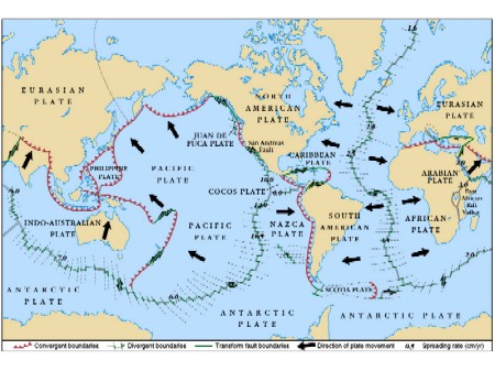
Here are where all the world's volcanoes are located...
http://www.intute.ac.uk/hazards/images/volcano_world.gif
Here's what happens when the gases start to come up from the mantle...
http://www.youtube.com/watch?v=VaChWgbn18Y
Fault Lines
http://www.jochemnet.de/fiu/earth3.jpg
The Ring of Fire
http://share1.esd105.wednet.edu/bishopcj/AU/essimages/ring_of_fire_red.GIF
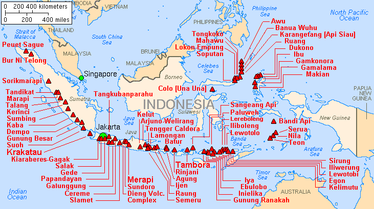
What happens when your country is on the Ring of Fire? Just ask Indonesia, Alaska, and Japan...
http://upload.wikimedia.org/wikipedia/commons/f/f5/Map_indonesia_volcanoes.gif
http://upload.wikimedia.org/wikipedia/commons/4/4d/Map_of_alaska_volcanoes_carlisle.jpg
http://virgil.org/dswo/fs/japantour/shared/japan-volcanoes.gif
http://www.nuuanu.k12.hi.us/G-1/public_html/websites/Lance/images/volcano.jpg
Here are where all the world's volcanoes are located...
http://www.intute.ac.uk/hazards/images/volcano_world.gif
Here's what happens when the gases start to come up from the mantle...
http://www.youtube.com/watch?v=VaChWgbn18Y
Fault Lines
http://www.jochemnet.de/fiu/earth3.jpg
The Ring of Fire
http://share1.esd105.wednet.edu/bishopcj/AU/essimages/ring_of_fire_red.GIF
What happens when your country is on the Ring of Fire? Just ask Indonesia, Alaska, and Japan...
http://upload.wikimedia.org/wikipedia/commons/f/f5/Map_indonesia_volcanoes.gif
http://upload.wikimedia.org/wikipedia/commons/4/4d/Map_of_alaska_volcanoes_carlisle.jpg
http://virgil.org/dswo/fs/japantour/shared/japan-volcanoes.gif
Hydrologic Cycle
Here are some drawings of what happens during the Hydrologic Cycle.
http://www.solcomhouse.com/images/hydroweath.jpg
http://www.buffer.forestry.iastate.edu/Photogallery/illustrations/Images/Hydrologic-Cycle.jpg
This one has some definitions for you!
http://www.google.com/imgres?imgurl=http://www.environment-canada.ca/water/images/nature/prop/hydrologic-rev.gif&imgrefurl=http://www.environment-canada.ca/water/en/nature/prop/e_cycle.htm&h=301&w=450&sz=22&tbnid=m8QCtuEdY4wa4M:&tbnh=85&tbnw=127&prev=/images%3Fq%3Dhydrologic%2Bcycle&hl=en&usg=__lTsLC9Zp5r7YNta2d8DvRwFq6kw=&ei=DUbJSqzIHYWO6AOqhZjwBA&sa=X&oi=image_result&resnum=6&ct=image
Hydrologic Cycle
Here are some drawings of what happens during the Hydrologic Cycle.http://www.solcomhouse.com/images/hydroweath.jpghttp://www.buffer.forestry.iastate.edu/Photogallery/illustrations/Images/Hydrologic-Cycle.jpgThis one has some definitions for you!http://www.google.com/imgres?imgurl=http://www.environment-canada.ca/water/images/nature/prop/hydrologic-rev.gif&imgrefurl=http://www.environment-canada.ca/water/en/nature/prop/e_cycle.htm&h=301&w=450&sz=22&tbnid=m8QCtuEdY4wa4M:&tbnh=85&tbnw=127&prev=/images%3Fq%3Dhydrologic%2Bcycle&hl=en&usg=__lTsLC9Zp5r7YNta2d8DvRwFq6kw=&ei=DUbJSqzIHYWO6AOqhZjwBA&sa=X&oi=image_result&resnum=6&ct=image
Friday, October 2, 2009
Subscribe to:
Comments (Atom)